
An Interactive 3D Physical Model for Real-Time Management of the Built Environment
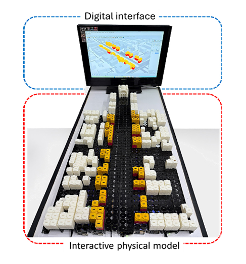
Abstract: This paper presents “City-Pixel”, an innovative interactive 3D physical model designed for intelligent and real-time management of the built environment. The system combines modular 3D-printed pixels with a digital platform to enable dynamic assessments of urban indicators such as land use intensity, building density, and mobility patterns. By integrating physical modeling with GIS databases and Urbano software, City-Pixel facilitates collaboration among diverse stakeholders, including urban planners, policymakers, and developers. The system’s architecture emphasizes user interaction, scalability, and real-time feedback, enhancing decision-making processes in urban planning. The Heliopolis case study demonstrated the system’s efficacy in improving spatial awareness and adaptability across various urban scales while visualizing alternative scenarios for sustainable development. Although hardware limitations related to the ESP32 microcontroller and I2C protocol pose scalability challenges, future research will focus on optimizing components, refining user interfaces, and conducting extensive validation testing. City-Pixel represents a novel approach to urban planning by connecting tangible user interfaces with real-time digital analytics, promoting inclusive, data-driven decision-making for sustainable urban development.
City-Pixel: An Interactive Method for Architectural and Urban Design, Bridging Physical and Digital Realms
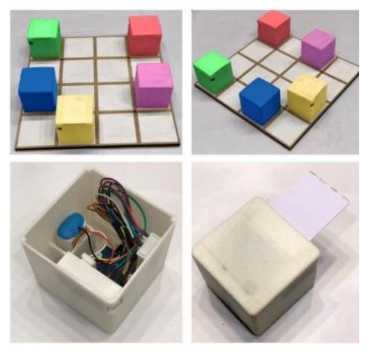
Abstract: The integration of physical models with real-time digital evaluation and feedback enhances urban planning and design. City-Pixel operates by using 3D-printed pixels equipped with RFID tags and Arduino microcontrollers to represent urban elements. These pixels are placed on a grid mat, allowing real-time capture of their positions. The system then processes this data through software to perform various urban analyses. This novel method integrates physical representations of the built environment with sophisticated digital technology, enabling data-informed decision-making and improving collaboration among stakeholders. This paper examines City-Pixel, an innovative method that seamlessly integrates physical and digital components in architectural and urban design. The aim is to assess the tool's potential benefits, limitations, and transformative capacity to alter conventional design processes through instantaneous analysis and feedback on an actual built environment. The study analyzes this innovative design method and its unique capability of seamlessly integrating hardware and software components, exploring a complex technological framework that facilitates seamless interaction between physical and digital aspects. Defined assessment criteria, encompassing usability, real-time responsiveness, and design flexibility, are established to evaluate the tool's efficacy. The study clarifies the software design of City-Pixel, revealing its foundational architecture, algorithms, and user interfaces. The physical representation of the new method is meticulously examined, encompassing its manufacturing process, utilizing materials, fabrication techniques, and assembly sequence. City-Pixel enables thorough geographical analysis by integrating current technology, hence improving informed decision-making and planning. Its ability to deliver real-time data and feedback improves stakeholder collaboration, bridging gaps and fostering sustainable, efficient urban development. The implementation of this new method has significant implications for architecture and urban design. City-Pixel introduces an innovative methodology in architectural and urban design by effectively integrating physical and digital domains. Its revolutionary methodology provides a comprehensive platform for real-time assessment of urban environments, promoting data-driven decision-making and collaborative design processes, so revolutionizing the future of urban planning and development.
CITY-Pixels: An Integrated Hardware-Software Framework for Real-Time Interactive Urban Modelling
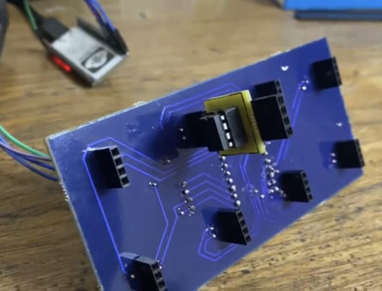
Abstract: This paper presents CITY-Pixels, an innovative hardware-software framework designed for real-time interactive urban modeling. The system combines sensor networks, communication protocols, and software solutions to create a platform for urban data collection, processing, and display. CITY-Pixels utilizes a hybrid communication strategy that combines I2C protocol and wireless networking to overcome traditional limitations in urban-scale data management. The hardware architecture includes environmental sensors, traffic monitors, and urban data collection devices, all connected by a data transmission infrastructure. The software framework combines real-time data processing, 3D visualization, and optimization algorithms for urban predictive analysis. This strategy enables exceptional scalability, efficiency, and real-time functionality in urban modeling. Case studies demonstrate the framework's effectiveness in traffic optimization, environmental monitoring, and urban planning. CITY-Pixels represents a significant advancement in smart city technologies, offering urban planners, politicians, and researchers a valuable tool for understanding and managing complex urban environments in real-time.